
Spotty morning showers, followed by clouds and sun with a few late day pop-up storms.
PHOENIX — Following some showers and rumbles of thunder this morning in south-central Arizona, shower and storm activity will shift focus primarily to more typical Arizona high terrain areas in the afternoons and evenings for the next several days.

Steady-state above normal temperatures are expected daily through the next week with lower desert highs in the 105 to 109 degree range.
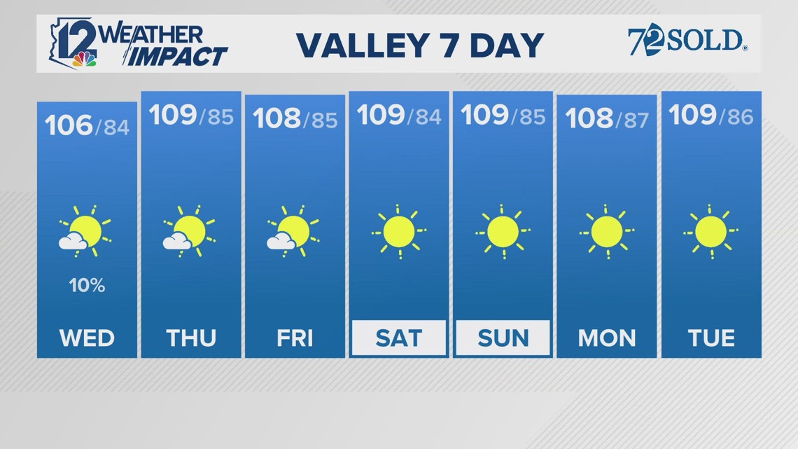
Seven-Day Forecast
WEDNESDAY: 106/84 AM shower
THURSDAY: 109/85 Clearing and warm
FRIDAY: 108/85 Above normal
SATURDAY: 109/84 Mostly Sunny
SUNDAY: 109/85 Mostly Sunny
Monsoon Meter Wednesday
MOGOLLON RIM AND WHITE MOUNTAINS: 5
Arizona Weather
Arizona has seen its fair share of severe weather throughout the state. Watch a compilation of videos from various thunderstorms, floods, and fires from across the Grand Canyon State on our 12News YouTube channel here.
Be sure to subscribe and see the latest in Arizona weather news and breaking weather emergencies throughout the Valley!
If you see storms, dust, beautiful sunsets, and more and you can safely do so, please share your photos and videos with us in the 12 News app, at [email protected], or on social media using the hashtag #BeOn12.
Download the 12 News KPNX app for Arizona weather updates:
iPhone: http://12ne.ws/iphone
Android:
Source link
Ginger Jeffries Phoenix area weather forecast by 12News www.12news.com
KPNX Arizona Local News Feed: weather 2024-08-28 12:43:20
forecast,weather,arizona,valley,instagram,news,local,syndication,home +


GIPHY App Key not set. Please check settings